"What therefore God hath joined together, let not man put asunder...." Traffic engineers and God...there's a joke or three in there somewhere. It seems, at least historically, that traffic engineers are experts at tearing asunder - our communities and the very earth our communities are built upon. In New Rochelle one of these sunderings is the Interstate 95. It knifes it way across New Rochelle - east / west - and is particularly noticeable near the train station.
Walking around not only slows us down to see more but also hear more. And a lot of what we hear is traffic. And the worst of that traffic noise comes from highways like the I-95. Walking anywhere near the I-95 always makes me imagine the neighborhood I'm walking as it was before the engineers were inspired to sunder it. How many homes were removed? What did they look like? What were the gardens like? Were there parks? Stores? Businesses? How was the access? How did people mostly get around? Were there fights at City Hall over the highway? (I bet there were) Who was for and who was against? What did the debates sound like? Who gained, who lost? What is it like to live in this neighborhood now? Can we better mitigate the noise pollution and the scarring?
The I-95 is BIG. It runs from the Canadian border all the way to Miami, Florida and is regarded as one of the most significant highways in this vast country. The NY portion was completed in 1958 and, as noted above, runs right through New Rochelle. It has its own canyon right in front of the train station. New Rochelle also has the distinction of having the last north bound exits before the only toll plaza (at Larchmont) on the I-95 in the state of New York. There is some local muttering about what the placement of this toll does to traffic flows on our local streets but I haven't found any research on whether people really do get off the highway to avoid the toll and if they do, whether that means they stop and spend money in New Rochelle, or stay in their cars and simply clog up our streets? Anyone looking for a research project? What I find odd about this toll is that it is only on the highway itself and not on the exits. While the New Jersey Turnpike, which doubles as the I-95 for part of its length, has toll plazas on all the entries and exits, here in New York you don't pay a toll if you exit the highway and drive through New Rochelle.
The I-95 is cutting off what could have been, and was planned to be, an amazing public space. And the irony is that it runs smack in front of the train station and according to the American Public Transport Association (APTA) every person we can get off the I-95 and into our trains will reduce CO2 emissions by 4,800 pounds per year for a 20 mile round trip commute. "A 10% reduction in all greenhouse gases produced by a typical two-adult, two-car household". So....all those drivers on the I-95, how many of you are commuting and what can we do to get you out of your cars and onto trains?
One way is to make walking to and from the train station more enjoyable than driving and one option to do this is to bury the highway and turn the resulting open space into a town square. Early plans, from way before the I-95, included gardens in front of the station. Check out the images below for what was envisioned, what we have now and what the future could look like.
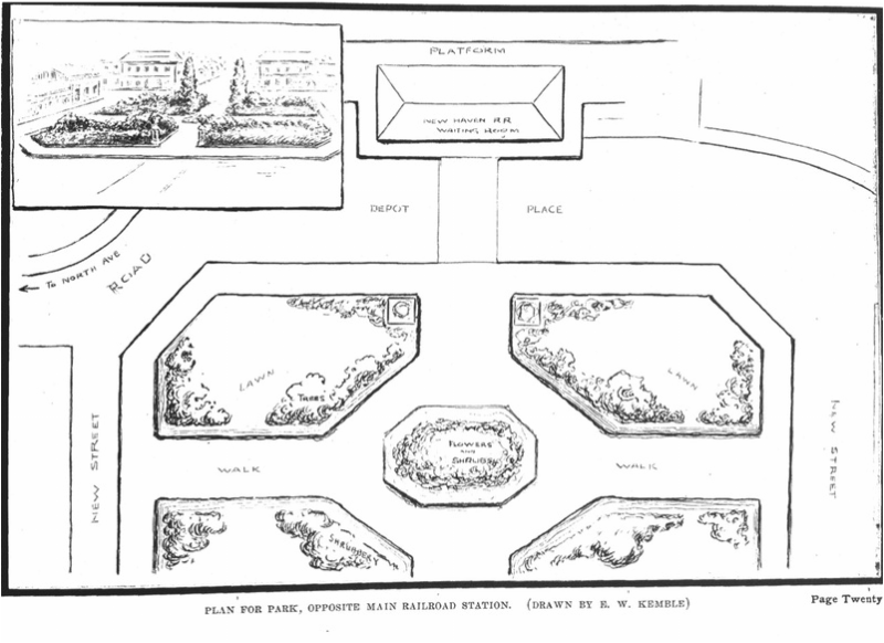
The drawing below was the plan. The train station is at the top and the park sits below (in front) of the station's main entrance. Imagine walking out of the train station after a day in an office in the city and walking through this garden on your way home. Or through a plaza with some places to sit, have a drink, a bite to eat, all while knowing you are within walking distance of home. What a great way to decompress, relax and move from work focus to home mode.
(Many thanks to Barbara Davis our city historian for the illustration).
(Many thanks to Barbara Davis our city historian for the illustration).
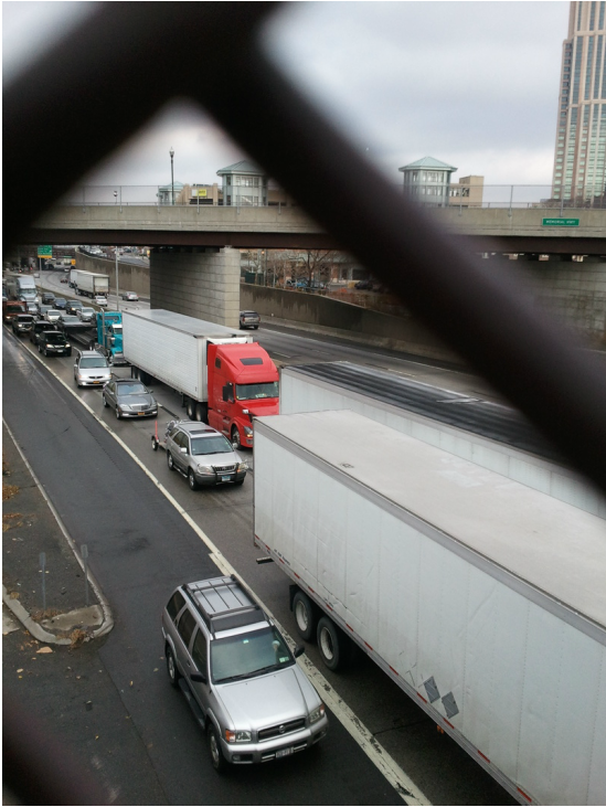
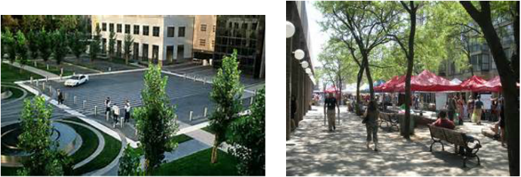
Here's what we have now. The train station is on the right. The two small matching towers are the top of the parking building next to the train station. Cars can also be seen parked in front of the station building.
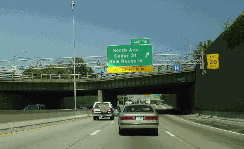
The 2002 photo below shows the northbound New England Thruway (I-95) at EXIT 16 (North Avenue) close to the train station. (Photo by Jim K. Georges.) This photo comes from NYC Roads a great site to read about the history of the I-95. Here in New Rochelle we may consider ourselves lucky. Unlike Larchmont next door, we did not lose our train station. And while in Larchmont the Interstate is covered over at the train station, the resulting space is not a green area but a car park for commuters.
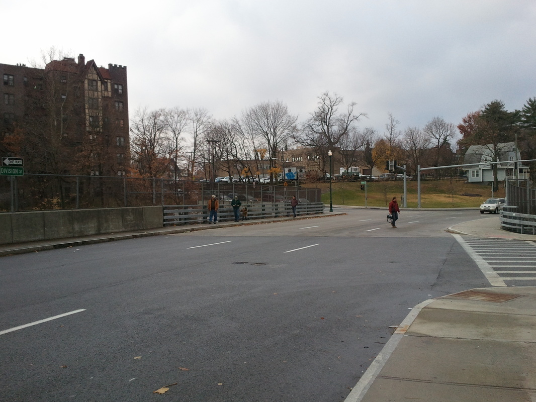
And here is the Division Street entrance to the train station. Note the lack of pedestrian crossings.
Think for a moment about how we could transform this area by covering over the highway at the train station. We can create a tremendous public space, a town square. Here's a few examples of how it could look courtesy of Bing.
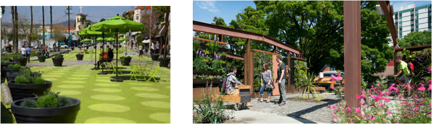
How different would it feel to come home to a space like this rather than battling with traffic and the noise of the interstate? What makes this idea even more appealing is that the train station sits very close to the original center of New Rochelle. A center that is no longer marked as a 'place'. We have the library green but no town square, no gathering place to mark the physical center of this historic Huguenot city currently celebrating its 325th anniversary.
 RSS Feed
